 Français
 Español
 Italiano
 Deutsch
 Português
 Русский
 Nederlands
 English
Contents
- At a glance
- Where is Cape Verde on the world and Africa map?
- The ten islands: Barlavento and Sotavento
- What characterizes each island
- Area of the ten islands
- Distances between islands and connections
- Airports: which island has what?
- Sal or Boa Vista: which one to choose?
- What is the best month to visit Cape Verde?
- Frequently asked questions
- Sources
Cape Verde is an archipelago of ten islands in the Atlantic, about 620 km from the coast of Senegal for the islands closest to the continent. On a map of Africa, look for a small string of dots west of Dakar. Here you’ll find the map, the islands one by one, the distances, the airports and the best time to go.
At a glance
- Where? In the Atlantic, between 14° and 17° north latitude and 22° and 25° west longitude, about 620 km from Senegal for the island closest to the continent (French Ministry of Foreign Affairs factsheet).
- Which country? The Republic of Cape Verde (Cabo Verde), an independent country. Capital: Praia, on the island of Santiago.
- Size: about 4,033 km² (CIA World Factbook), 491,233 inhabitants at the 2021 census (final results from INE).
- Ten islands, two groups: Barlavento (windward, north) and Sotavento (leeward, south). Santa Luzia is uninhabited.
- International airports: Sal, Boa Vista, Praia and São Vicente. Santo Antão, Brava and Santa Luzia have no operating airport.
- Between the islands: CVsky operates domestic flights since 29/03/2026; ferries are run by CV Interilhas (and Nôs Ferry between São Vicente and Santo Antão).
- Best time: November or December for a first trip, just after the rainy season (July to October); the dry season runs from November to June.
Planning a trip to Cape Verde?
Tell us about your project: we’ll connect you with a local agency that knows every island and will prepare a proposal tailored to your wishes and your budget.

Where is Cape Verde on the world and Africa map?
Cape Verde is an archipelago in the North Atlantic, off the coast of Senegal and Mauritania, between 14° and 17° N and 22° and 25° W. It stretches about 270 km from north to south and 290 km from east to west (distances calculated by us from airport coordinates). Do not confuse it with the Cape Verde peninsula on the mainland, which is home to Dakar: it gave its name to the country, but it is not part of it.
In practical terms: there is no land border, only sea. You get there by plane, through Sal, Boa Vista, Praia or São Vicente. Depending on the source, the distance to the mainland is sometimes given as around 500 km; we use the 620 km from the French Ministry of Foreign Affairs factsheet for the closest islands. For flights and airlines, see our guide to Cape Verde airports.
The ten islands: Barlavento and Sotavento
The archipelago is divided into two groups, based on exposure to the northeast trade winds: Barlavento (windward) in the north, Sotavento (leeward) in the south.
| Group | Islands |
|---|---|
| Barlavento (north) | Santo Antão, São Vicente, Santa Luzia, São Nicolau, Sal, Boa Vista |
| Sotavento (south) | Maio, Santiago, Fogo, Brava |
This division does not separate tourism from wilderness: Sal and Boa Vista, the two islands known for their great beaches, are in the north, while Santiago, the most populous, is in the south.
What characterizes each island
North: Barlavento
Santo Antão is the most mountainous of the northern islands, the queen of hiking, with green valleys and coastal trails. No airport: you reach it by ferry from São Vicente.

São Vicente is the island of Mindelo, the cultural and musical capital, with its harbour and its nightlife. It is also the gateway to Santo Antão.
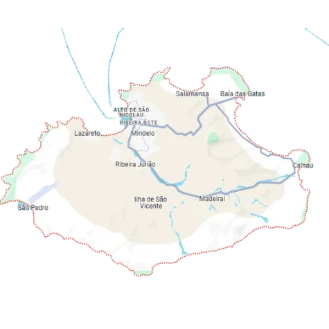
Santa Luzia is uninhabited and has no airport. It can be seen from São Vicente; it serves as a nature reserve.
São Nicolau is a quiet island of mountains and traditions, with a small airstrip at Preguiça. It suits travellers who want to step off the well-trodden tourist paths.

Sal is flat and arid, geared toward the beach and watersports around Santa Maria. Boa Vista is the larger of the two, made up of dunes, long beaches and sea turtles.


South: Sotavento
Maio is the quiet island with vast beaches and marine wildlife, the closest to Praia. Santiago is the largest island (991 km²): Praia, Cidade Velha, the history and culture of the country.

Fogo is dominated by Pico do Fogo (2,829 m), the highest point in the country, with a volcano you can climb. Brava, the smallest inhabited island, is quiet and has no airport: you reach it by ferry from Fogo.

To decide between these ten profiles, read Cape Verde: which island to choose based on your expectations. If you’d rather have someone make that choice for you, describe your project to our partner local agency and receive a suggested itinerary.
Area of the ten islands
| Island | Group | Area |
|---|---|---|
| Santiago | Sotavento | 991 km² |
| Santo Antão | Barlavento | 779 km² |
| Boa Vista | Barlavento | 620 km² |
| Fogo | Sotavento | 476 km² |
| São Nicolau | Barlavento | 343 km² |
| Maio | Sotavento | 269 km² |
| São Vicente | Barlavento | 227 km² |
| Sal | Barlavento | 216 km² |
| Brava | Sotavento | 64 km² |
| Santa Luzia (uninhabited) | Barlavento | 35 km² |

The total area of the ten islands is about 4,020 km² (4,033 km² according to the CIA World Factbook). In terms of population, the country had 491,233 inhabitants at the 2021 census (final results from INE). According to the preliminary results, the municipality of Praia accounts for 29.6% and that of São Vicente for 15.3%. Boa Vista, the third largest island, is by contrast sparsely populated: this is what leaves so much room for deserted beaches.
Distances between islands and connections
The distances below are as the crow flies, calculated from airport or port coordinates. The flight time from Praia to Sal is about 40 minutes; the ferry crossing from São Vicente to Santo Antão takes 40 to 60 minutes.
| Route | Distance (as the crow flies) | Connection |
|---|---|---|
| Sal – Boa Vista | about 70 km | Straight-line distance only |
| Sal – São Vicente | about 220 km | Straight-line distance only |
| Sal – Praia | about 210 km | CVsky flight, about 40 min |
| Praia – São Vicente | about 270 km | CVsky flight |
| Praia – Maio | about 40 km | CVsky flight, CV Interilhas ferry |
| Praia – Fogo | about 110 km | CVsky flight, CV Interilhas ferry |
| São Vicente – São Nicolau | about 90 km | CVsky flight |
| Mindelo – Porto Novo (Santo Antão) | about 17 km | Ferry, 40 to 60 min |
Domestic flights are operated by CVsky: operating certificate issued on 24/12/2025, ticket sales opened on 26/02/2026, fleet of ATR 72-600 aircraft (two planes at launch, a third delivered in October 2026). International flights are operated by Cabo Verde Airlines and European airlines. On the sea side, CV Interilhas experienced disruptions in 2025: in August, the Fogo–Brava–Santiago route had only three sailings a week, compared with one daily (except Sunday) previously. In practical terms: allow some slack in your schedule if you include Brava. All the details are in How to get around between the Cape Verde islands. To build a realistic route, have your inter-island itinerary checked by the local agency.
Airports: which island has what?
| Island | Airport | Use |
|---|---|---|
| Sal | Sal | International |
| Boa Vista | Boa Vista | International |
| Santiago | Praia | International |
| São Vicente | Mindelo | International |
| Fogo | São Filipe | Domestic |
| Maio | Maio Airfield | Domestic |
| São Nicolau | Preguiça | Domestic |
| Santo Antão, Brava, Santa Luzia | None in operation | Access by boat |
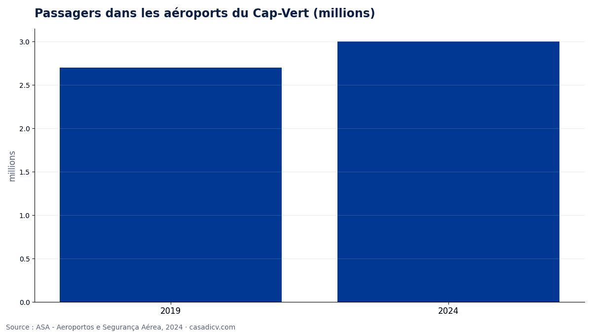
The control towers of ASA (Aeroportos e Segurança Aérea) are at Sal, Praia, Boa Vista and São Vicente. Sal and Boa Vista handle more than half of the traffic, which is why most direct flights from Europe land there. Airport traffic rose from 2.7 million passengers in 2019 to about 3 million in 2024.
Planning a trip to Cape Verde?
Tell us about your project: we’ll connect you with a local agency that knows every island and will prepare a proposal tailored to your wishes and your budget.
Sal or Boa Vista: which one to choose?
We decide by traveller profile. Both islands offer sunshine almost all year round and beaches; the difference lies in size and pace.
| Profile | Our pick | Why |
|---|---|---|
| Couples or friends who want nightlife, restaurants and walking-distance outings | Sal | Small island (216 km²): everything is close to the airport, around Santa Maria |
| Watersports | Sal | Kitesurfing, windsurfing and diving spots close to town |
| Family on an all-inclusive package | Boa Vista | 620 km² island, nearly three times the size of Sal: large beaches and secluded resorts, quieter |
| Peace and quiet, dunes and sea turtles | Boa Vista | Dunes, vast beaches, space; you’ll need to rent a car or take a taxi to get around |
In short: Sal if you want life around you, Boa Vista if you’re looking for space. The two islands can be combined, but expect one CVsky flight with a possible connection in Praia. To see more than the beach, check out our ideas for a 3-island itinerary or the page Sal: beaches and watersports.
What is the best month to visit Cape Verde?
| Period | What to expect |
|---|---|
| November to June | Dry season |
| July to October | Rainy season, short and irregular |
| February to April | Coolest sea (February to April), around 23 °C in Praia |
| September and October | Warmest sea, close to 27 °C in Praia in September (2025 readings) |
Rainfall remains low: about 222 mm per year in Praia (ERA5 reanalysis, 2000-2025), and Sal is the driest island. Our clear recommendation: November or December for a first trip. The rains are over, the landscapes are still green (useful for hiking on Santo Antão), and the sea keeps the warmth of autumn. March to June also works well if you prefer dry, stable weather. Details are in When to go to Cape Verde, and to pin down your dates, ask the local agency for the best period for your island.
Frequently asked questions
Where is Cape Verde on the map of Africa?
Cape Verde is an archipelago in the Atlantic, west of Africa, between 14° and 17° north latitude. The island closest to the continent is about 620 km from Senegal, according to the French Ministry of Foreign Affairs factsheet.
Cape Verde: what country is it?
Cape Verde (Cabo Verde) is an independent island country in West Africa. Its capital is Praia, on the island of Santiago, and it had 491,233 inhabitants at the 2021 census.
How many islands does Cape Verde have?
Ten islands, nine of which are inhabited. Barlavento, in the north: Santo Antão, São Vicente, Santa Luzia, São Nicolau, Sal, Boa Vista. Sotavento, in the south: Maio, Santiago, Fogo, Brava.
What are the airports in Cape Verde?
Four international airports: Sal, Boa Vista, Praia and São Vicente. Three domestic airports or airstrips serve Fogo (São Filipe), Maio and São Nicolau (Preguiça).
How do you travel from one island to another?
By plane with CVsky, the domestic airline since 29/03/2026, or by ferry with CV Interilhas, and Nôs Ferry between São Vicente and Santo Antão. The Sotavento ferries experienced disruptions in 2025.
Which is better, Sal or Boa Vista?
Sal for nightlife, restaurants and watersports around Santa Maria; Boa Vista for space, dunes, large beaches and quiet. The two islands can be combined, but expect one CVsky flight with a possible connection in Praia.
What is the most beautiful island in Cape Verde?
It depends on your plans: Sal and Boa Vista for beaches, Santo Antão and Fogo for hiking, São Vicente and Santiago for culture and music.
What is the best month to visit Cape Verde?
We recommend November or December for a first trip: the rains, from July to October, are over, the landscapes are still green and the sea remains warm. March to June also works well for dry weather.
Sources
- French Ministry of Foreign Affairs factsheet, cited by the Lille academy (accessed 2026-10)
- CIA World Factbook – Cabo Verde (accessed 2026-10)
- FAO Cabo Verde – the country at a glance (island areas) (accessed 2026-10)
- INE Cabo Verde via RTP – 491,233 residents in 2021 (RGPH-2021) (accessed 2026-10)
- INE Cabo Verde via RTP – preliminary RGPH-2021 results (483,628) (accessed 2026-10)
- INE Cabo Verde – RGPH-2021, preliminary results (PDF) (accessed 2026-10)
- ASA Cabo Verde – airports (accessed 2026-10)
- ASA Cabo Verde – Preguiça airfield (accessed 2026-10)
- ASA Cabo Verde – Check-In newsletter no. 10 (accessed 2026-10)
- CVsky – AOC certification and launch of inter-island flights (accessed 2026-10)
- CVsky – ticket sales, IATA summer 2026 (accessed 2026-10)
- Inforpress – CV Interilhas, Sotavento contingency plan (accessed 2026-10)
- Inforpress – CV Interilhas without ships to serve Maio, Fogo and Brava (accessed 2026-10)
- Forbes Africa Lusófona – 3 million airport passengers in 2024 (ASA data) (accessed 2026-10)
- weatherbox.io – Praia (ERA5, 2000-2025) (accessed 2026-10)
- weather-stats.com – sea temperature in Praia (accessed 2026-10)
- temperaturadomar.pt – sea temperature in Praia, month by month (accessed 2026-10)
Are you planning a trip to Cape Verde?
To organize your stay, we work with a local agency based in Cape Verde, which knows the archipelago island by island. Tailor-made tours, accommodation, inter-island flights, excursions: describe your project, we put you in touch and the agency prepares a proposal tailored to your wishes and budget.

Written by Adilson Gomes Garcia
Founder of Casa di CV and Gomia-Voyage, I was born in Santiago and I am committed to showcasing African territories, starting with Cape Verde. Through my platforms, I help travelers and curious minds better understand these destinations, their cultures and their realities, so they can plan authentic and respectful trips. My goal: to offer a clear, local and useful perspective for discovering Africa as it really is, with its riches and its identity.