Cape Verde, a unique hiking destination
Cape Verde is an archipelago of ten volcanic islands off the West African coast. Its varied landscapes, between mountains, valleys, arid plateaus and beaches, make it an ideal place for hiking enthusiasts. Each island offers a different experience, allowing travelers to immerse themselves in nature while discovering the local culture.
Why is Cape Verde perfect for trekking?
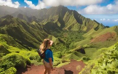
Cape Verde offers trails for all levels, from beginners to experienced hikers. Santo Antão, with its breathtaking landscapes and cliffside paths, is considered a true paradise for hiking enthusiasts. The island of Fogo offers the chance to climb an active volcano. Whether you're looking for a challenging hike, a leisurely stroll along the coast, or a cultural immersion in the villages, Cape Verde has something to charm everyone.
The trails are often marked, although some routes require a guide due to the difficulty. The diversity of the islands allows for different circuits to be combined, offering varied experiences.
Looking for a sports holiday in Cape Verde?
We have negotiated low rates with our partners. Whether you need a tailor-made tour, accommodation or simply local activities, let us know your needs and we will redirect you to the service provider you need.
General tips for hiking in Cape Verde
Before you leave, it is essential to be well prepared. The climate is tropical and arid, with temperatures that vary according to the seasons and the islands. The best times for hiking are from November to June, when temperatures are moderate and the risk of rain is low. Here are some tips:
- Recommended Equipment : Wear good shoes, bring water, sunscreen, and clothing appropriate to the weather conditions.
- Caution and Safety : Prefer to hike in a group, especially on isolated trails. Always inform someone of your route if you are going alone.
- Respect for Nature and Inhabitants : Respect the environment by leaving no waste, and be respectful of local communities.
The best hiking trails in Cape Verde
Cape Verde is full of trails, but we have selected seven iconic and varied routes, suitable for all levels. These circuits will make you discover different aspects of the archipelago: volcanic climbs, coastal walks, valley crossings. Here is our selection of the best hikes not to be missed:
- Hike from Cova to Paul, Santo Antão – Moderate level, green valleys.
- Ascent of Pico de Fogo, Fogo Island – Difficult level, volcanoes and panoramic views.
- Coastal path from Ponta do Sol to Cruzinha, Santo Antão – Moderate level, coastal landscapes.
- Monte Verde, São Vicente – Easy level, views of Mindelo.
- Brava Plateaus – Moderate level, green and peaceful island.
- Ribeira Grande in Chã de Igreja, Santo Antão – Moderate level, immersion in nature.
- Hiking in the Serra Malagueta Natural Park, Santiago – Moderate level, mountainous landscapes and green valleys.
- Hike from Ribeira Brava to Monte Gordo, São Nicolau – Moderate to difficult level, mountainous landscapes.
In the following sections, we'll detail each route to help you plan your next Cape Verde adventure.
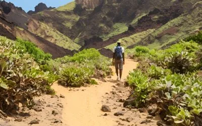
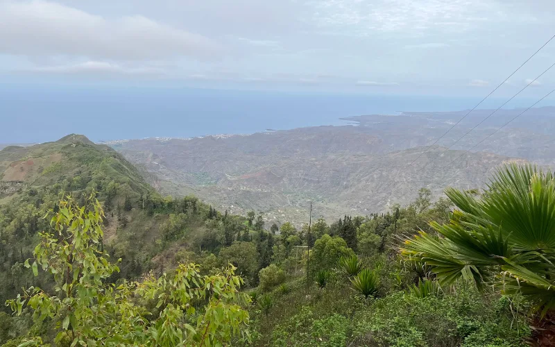
Hike from Cova to Paul, Santo Antão
This trail is one of the most popular in Santo Antão. It starts at the Cova Crater, an ancient volcano, and gradually descends towards the Paul Valley. The path is well marked, offering stunning views of the mountains and the lush vegetation of the valley.
- Level : Moderate
- Starting point : Cova Crater
- Distance : About 15 km (one way)
- Elevation : Descent of 1 m
- Estimated duration : 3 hours for the outward journey, 2 to 3 hours for the return journey
- Highlights : The green landscapes, the crossing of local villages, and the view from the Cova crater. This trail allows you to discover the diversity of flora and rural life of Santo Antão. You will be able to observe terraced crops typical of the island, where local farmers grow corn, yams and sugar cane. Along the way, it is not uncommon to come across welcoming locals, ready to share stories about life in the valley.
- Consulting : Start the hike early in the morning to take advantage of cooler temperatures and the best light conditions for your photos.
Ascent of Pico de Fogo, Fogo Island
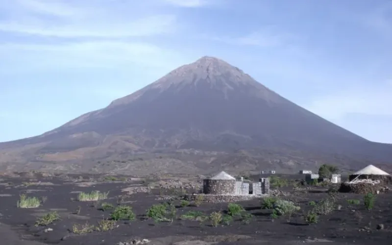
Climbing Pico de Fogo is a must-do experience for trekking enthusiasts. Pico de Fogo is the highest point in Cape Verde, with an altitude of 2 m. The climb offers spectacular views of the volcanic landscape, with rock formations and lava flows.
- Level : Difficult
- Starting point : Village of Chã das Caldeiras
- Distance : About 10 km (round trip)
- Elevation : 1 m climb
- Estimated duration : 4 to 5 hours for the ascent, 2 to 3 hours for the descent
- Highlights : The views from the summit, the unique experience of walking on an active volcano, and the impressive view of the crater. A guide is highly recommended for this hike, both for safety reasons and to enrich the experience with information about the geology and history of the island. The village of Chã das Caldeiras, located at the foot of the volcano, is also a point of interest. This village was rebuilt after the last eruption and offers an immersion in local life, with the opportunity to taste wine produced on the slopes of the volcano.
- Consulting : Bring a windproof jacket, as temperatures can be cool and windy at the summit. Stop on the way back to taste the local wine, called “Cha”. This adds an authentic touch to your adventure.
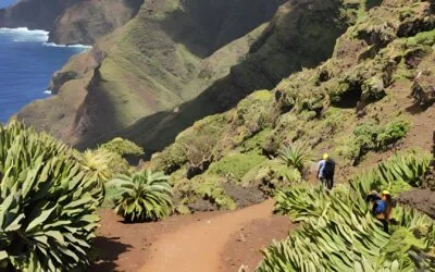
Coastal path from Ponta do Sol to Cruzinha, Santo Antão
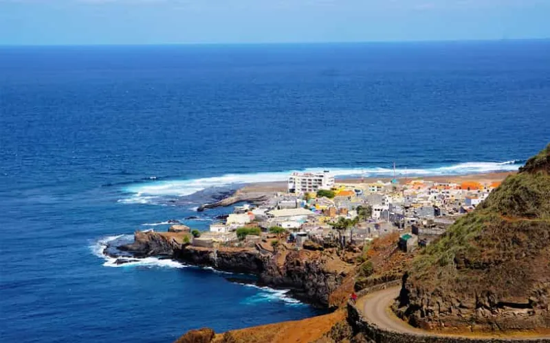
This coastal path is a classic of Santo Antão. It connects Ponta do Sol to Cruzinha, along impressive cliffs and passing through several small fishing villages. The route offers magnificent views of the Atlantic Ocean and allows you to observe the daily life of the inhabitants of the isolated villages.
- Level : Moderate
- Starting point : Ponta do Sol
- Distance : About 12 km (one way)
- Elevation : Moderate elevation, with regular climbs and descents
- Estimated duration : 4 to 5 hours for the outward journey
- Highlights : The spectacular ocean views along the way, the discovery of picturesque villages like Fontainhas, and the opportunity to interact with the locals. The trail is well maintained and accessible without a guide, but it is important to be careful, as some sections run along steep cliffs.
- Consulting : Take the time to stop at Fontainhas, one of the most photogenic villages on the island, with its colorful houses perched on the mountainside. In the morning, the light is perfect for memorable photos.
Monte Verde, São Vicente

Monte Verde is the highest point on the island of São Vicente. This easy hike takes you to the top, where you can enjoy panoramic views of the entire island, including Mindelo, Porto Grande Bay, and even neighboring islands on a clear day. The trail is short but offers a great experience of discovering the local flora.
- Level : Easy
- Starting point : Access road to Monte Verde
- Distance : About 5 km (round trip)
- Elevation : 750 m climb
- Estimated duration : 2 to 3 hours for the round trip
- Highlights : The panoramic views from the summit, the endemic flora, and the opportunity to discover a lesser-known side of São Vicente. Monte Verde is also an ideal place to observe local birds and enjoy the tranquility of the landscape.
- Consulting : Monte Verde can be windy, so consider bringing a jacket. The best time to visit is in the morning, when the sky is often clearer and the views are at their best.
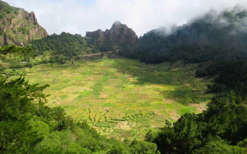
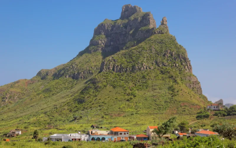
Brava Plateaus
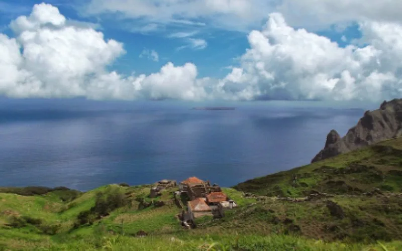
Brava Island is the smallest of the inhabited islands of Cape Verde, but it is renowned for its lush green landscapes and beautiful plateaus. This hike will take you through the Brava plateaus, crossing rural landscapes, cultivated fields and acacia forests.
- Level : Moderate
- Starting point : Vila Nova Sintra
- Distance : About 10 km (round trip)
- Elevation : Moderate difference in altitude
- Estimated duration : 3 to 4 hours for the round trip
- Highlights : The tranquility of the island, the agricultural landscapes, and the panoramic views from the plateaus. Brava is known as the island of flowers because of its lush vegetation, and this hike allows you to fully appreciate this natural wealth.
- Insider Tip : Bring a picnic and enjoy a break on one of the plateaus to admire the view. The inhabitants of Brava are particularly welcoming, and it is not uncommon to be invited to share a coffee or a meal.
Ribeira Grande in Chã de Igreja, Santo Antão
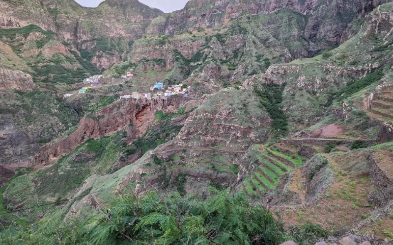
This trail takes you through the Ribeira Grande Valley, following the river and passing through several small villages. It is an immersive hike that allows you to discover the rural life of Santo Antão, while enjoying spectacular landscapes.
- Level : Moderate
- Starting point : Ribeira Grande
- Distance : About 14 km (one way)
- Elevation : Moderate difference in altitude
- Estimated duration : 5 to 6 hours for the outward journey
- Highlights : Crossing the villages of Boca de Coruja, Coculi, and Caibros, the beauty of the valley's landscapes, and the warm welcome of the locals. The trail is punctuated by magnificent viewpoints of the mountains and the river.
- Consulting : Take small gifts (like fruit or sweets) for the children in the villages you pass through. This creates unforgettable moments of sharing with the local community.
Hiking in the Serra Malagueta Natural Park, Santiago
The Serra Malagueta Natural Park, located in the north of the island of Santiago, is an ideal place to discover the biodiversity of Cape Verde. The trail crosses mountainous areas, green valleys, and offers spectacular views of the ocean and the surrounding area.
- Level : Moderate
- Starting point : Entrance to the Serra Malagueta Park
- Distance : About 8 km (round trip)
- Elevation : 600 m climb
- Estimated duration : 3 to 4 hours for the round trip
- Highlights : The park's unique biodiversity, including endemic species of plants and birds, as well as panoramic views of Santiago Island, make this park a true treasure for nature lovers.
- Consulting : Visit the park early in the morning to observe birds in their natural habitat. A local guide can help you spot endemic species and better understand the park's ecosystem.
Hike from Ribeira Brava to Monte Gordo, São Nicolau
This hike takes you from Ribeira Brava, the historic capital of São Nicolau, to Monte Gordo Natural Park, the highest point on the island. Monte Gordo is renowned for its lush vegetation, a rarity in the archipelago, and offers stunning views of the island and the Atlantic Ocean.
- Level : Moderate to difficult
- Starting point : Ribeira Brava
- Distance : About 16 km (round trip)
- Elevation : 1 m climb
- Estimated duration : 6 to 7 hours for the round trip
- Highlights : Crossing Ribeira Brava, with its colonial architecture, gives you a glimpse of urban life in Cape Verde before starting the climb to Monte Gordo. The natural park is home to a great diversity of endemic plants, from pines to ferns, offering a unique contrast to the more arid landscapes of the other islands. At the top, you can admire a spectacular view of São Nicolau and, on a clear day, see the neighboring islands.
- Consulting : Start your hike early in the morning to avoid the high temperatures, especially during the ascent. Bring enough water and take advantage of the many lookout points along the way to rest and admire the views of the island.
Cape Verde is an ideal destination for hiking enthusiasts, offering a diversity of landscapes and trails suitable for all levels. From the green valleys of Santo Antão to the majestic volcanoes of Fogo, to the tranquil plateaus of Brava, each island offers a unique experience.
By exploring these trails, you will discover not only the natural beauty of the archipelago, but also the cultural richness and hospitality of its inhabitants. Prepare your hiking shoes, go on an adventure, and be amazed by the wonders that Cape Verde has to offer.